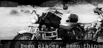
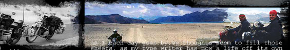
|
GREAT RANN OF KUTCH
Kutch in Gujarat is known to be the second largest district
in India and is sparsely populated. It is a dry belt with
the Great Rann to the north and the Little Rann to the east.
The Great and the Little Rann of Kutch are also the breeding
grounds of Flamingo, Pelican & Avocet and home of the
rare Indian Wild Ass, which is now a protected species. In
Kutch, I found India’s some of most exquisite handicrafts
like embroidery, tie 'n' die fabrics, enamelled silverware,
etc. It all started, as I couldn’t suppress any more
my quest to ride to India’s westernmost corner. I chose
the Greater Rann of Kutch (GRK). It constitutes the northern
part of Kutch region and spreads from the Rajasthan-Gujarat
Border, along the Indo-Pakistan border region to Lakhpat in
the west, near the Kori Creek.
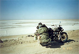
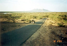
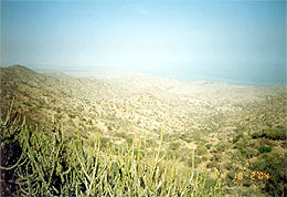
Once, not so long ago, GRK was a vast stretch of water, an
inlet of the Arabian Sea. Then the area got silted up leaving
flatlands which glitter with salt. When the monsoon drives
the sea inland, and floods the Rann, handsome wild asses gallop
across the saline desert and huddle together on the little
hillocks, called bets, which become islands in an inland sea.
I divided the GRK into four divisions on the basis of accessibility:
(i) Nadeshwari (Abode of Goddess in the middle of Rann)
(ii) Dholavira (Archeological site of world fame)
(iii) Khavda (Gateway to India’s some of the most unexplored
regions)
(iv) Lakhpat (Erstwhile seaport)
Nadeshwari
 I reached
the first post of BSF at around 6 pm. The men there were very
friendly and were awed by the fact that I came on a mobike
all the way from Delhi. They showed me the way to Nadeshwari.
While starting from there for Nadeshwari temple, I asked them
if I have to submit my camera and mobile. They promptly persuaded
(and not forced) me to submit the same because of the security
reasons. They also informed me that both the things would
be captured if I take them beyond this point. Nadeshwari is
basically a shrine of a Goddess. The way to reach the place
makes you ride in the middle of nowhere in GRK. Jeep tyres
made the dirt tracks that I followed. The BSF men instructed
me to keep to my right or I’ll end-up in the custody
at the Border. I followed the ‘rightest’ track
I could see, as I had no intention to cross the border. The
tracks were full of mud and it was very difficult to ride
on them. The scenery was breathtaking. The sun was about to
set and for miles I could only see the brownish-red muddy
plain landscape. The red color of sunrays and very light brown
of mud gave a peculiar mix. It is actually a vast, featureless,
endless salty terrain. I missed my camera, dearly that day.
I reached the second post of BSF at 7.20 pm. It was pitch
dark. I parked the bike before their tent and introduced myself.
The men enquired about various things and I answered them
to my sincerest extent. Then they asked to check the luggage
to which I readily agreed. I showed them each part of my luggage.
They took away the knife that I brought for cutting the lemons.
BTW, it is always good to carry lemons, sugar and salt of
which I carried only the former two, as I knew salt will never
be a problem in Kutch :-). They told me to ride straight and
after a while I was supposed to see some bulbs. I had absolutely
no idea where I was heading for. Riding was difficult. All
the lights that I have on my bike were on. After riding for
about 400 meters I saw some lights. I parked the bike before
the gate and went inside to ask whether I can stay. Seeing
a stranger, a lot of people congregated as if I was being
exhibited there. Language was a big problem. Nobody understood
what I meant. Then one servant who had served in Rajasthan
came out of kitchen. He could get my words and did an unpaid
translation for me. I was showed the way to the third BSF
post. “How many posts does BSF requires to check my
identity”, I wondered. It is a rule in the temple to
register every staying person with BSF. The post is only few
meters away from the temple complex. The BSF men appreciated
the spirit and asked me to take rest at the temple. I reached
the first post of BSF at around 6 pm. The men there were very
friendly and were awed by the fact that I came on a mobike
all the way from Delhi. They showed me the way to Nadeshwari.
While starting from there for Nadeshwari temple, I asked them
if I have to submit my camera and mobile. They promptly persuaded
(and not forced) me to submit the same because of the security
reasons. They also informed me that both the things would
be captured if I take them beyond this point. Nadeshwari is
basically a shrine of a Goddess. The way to reach the place
makes you ride in the middle of nowhere in GRK. Jeep tyres
made the dirt tracks that I followed. The BSF men instructed
me to keep to my right or I’ll end-up in the custody
at the Border. I followed the ‘rightest’ track
I could see, as I had no intention to cross the border. The
tracks were full of mud and it was very difficult to ride
on them. The scenery was breathtaking. The sun was about to
set and for miles I could only see the brownish-red muddy
plain landscape. The red color of sunrays and very light brown
of mud gave a peculiar mix. It is actually a vast, featureless,
endless salty terrain. I missed my camera, dearly that day.
I reached the second post of BSF at 7.20 pm. It was pitch
dark. I parked the bike before their tent and introduced myself.
The men enquired about various things and I answered them
to my sincerest extent. Then they asked to check the luggage
to which I readily agreed. I showed them each part of my luggage.
They took away the knife that I brought for cutting the lemons.
BTW, it is always good to carry lemons, sugar and salt of
which I carried only the former two, as I knew salt will never
be a problem in Kutch :-). They told me to ride straight and
after a while I was supposed to see some bulbs. I had absolutely
no idea where I was heading for. Riding was difficult. All
the lights that I have on my bike were on. After riding for
about 400 meters I saw some lights. I parked the bike before
the gate and went inside to ask whether I can stay. Seeing
a stranger, a lot of people congregated as if I was being
exhibited there. Language was a big problem. Nobody understood
what I meant. Then one servant who had served in Rajasthan
came out of kitchen. He could get my words and did an unpaid
translation for me. I was showed the way to the third BSF
post. “How many posts does BSF requires to check my
identity”, I wondered. It is a rule in the temple to
register every staying person with BSF. The post is only few
meters away from the temple complex. The BSF men appreciated
the spirit and asked me to take rest at the temple.
Few moments later, while lying down on my bed, I was wondering,
why do people live in so remote places? For the sake of information,
the temple has food facility. It is served twice a day. Free
of cost. For staying, they don’t have rooms but a big
shade. I slept there. It was cool. I guess, it will be difficult
for ladies. They may have some alternate arrangements for
ladies too but I didn’t see even a single female inhabitant
there. To explain you the whole place, it appears like a cow
shed at first glance centered by two temples. One old and
abandoned and the other new and currently consecrated. Both
temples have no architectural significance but the following
of the goddess is simply unimaginable. The place has a separate
running cowshed. The caretakers offered me a cot, quilt, etc.,
which I never needed as I was equipped. I was about to doze
off when two BSF men, who met at the second post, approached
me. They courteously asked for my passport and other documents
that I was carrying for identification. They informed me that
at the border, things are very difficult if a stranger comes
and stays and information of my stay here at the temple will
have to be passed on to the H.Q. at Dantiwada (Gujarat). I
complied. The documents were returned to me after about 30
minutes with apologies for botheration and the two personnel
bade me goodbye for rest of the night. It was 9:30 pm but
since it was not possible to converse with any of the men
in the temple complex (the translator for me disappeared)
so I thought it is best to sleep for an early start tomorrow.
After a relaxing nights sleep, I got up early in the morning
and had my daily chores completed, behind a bush, out in the
wild, on the silt of Rann :-) Although, the place has a small
doorless bathroom which is hardly covered. Water, of course,
is not a problem, but it tasted like brine. The temple has
a freshwater tank and luckily it was filled. I offered Puja
to the Goddess Nadeshwari at the temple firstly at 5:30 am
and then at 8:00 am. After exploring the place a bit and enjoying
the antics of wild assess I thought it best to move on to
the second section of the Rann instead of exploring the Pakistan
Border. Yes! A bit about wild assess first. Wild asses are
bigger than the donkey but smaller than horses. Mules will
be best to describe them height-wise. They are well built
and grayish. A white line runs on the back to the tail and
stomach portion is also light in color. They are great runners
and I could see it for myself when I chased them with my bullet.
They become out of sight within a matter of minutes. I had
to use the expertise of BSF men to spot them again. After
collecting my camera and mobile phone and clicking few photographs
of the Jalol village and adjoining Rann I started for the
second section – Dholavira.
^Top
DHOLAVIRA – The Lost World
 There
are actually two routes to Dholavira. I preferred the long
one because my objective was to cover the GRK to the extent
possible. One incidence I must tell you. I was reaching Fatehgadh.
The road bifurcated. I wanted the road to the Rann stretch.
But then the condition was that I should not end up routing
back to this bifurcation for catching the road to Dholavira.
I decided to ask a local. After waiting for around 10 minutes,
heard the sound of a mobike’s engine. When the biker
arrived, I waved to get his attention. He stopped. He was
in his thirties. I told him my query. He said road is butchered
by the tractors and is not negotiable. Then he suddenly said,”Achha
mere peeche aao”. Ok, follow me. Good luck for two reasons.
A hindi-speaking fellow and a benefactor :-) There
are actually two routes to Dholavira. I preferred the long
one because my objective was to cover the GRK to the extent
possible. One incidence I must tell you. I was reaching Fatehgadh.
The road bifurcated. I wanted the road to the Rann stretch.
But then the condition was that I should not end up routing
back to this bifurcation for catching the road to Dholavira.
I decided to ask a local. After waiting for around 10 minutes,
heard the sound of a mobike’s engine. When the biker
arrived, I waved to get his attention. He stopped. He was
in his thirties. I told him my query. He said road is butchered
by the tractors and is not negotiable. Then he suddenly said,”Achha
mere peeche aao”. Ok, follow me. Good luck for two reasons.
A hindi-speaking fellow and a benefactor :-)
I started trailing him. He entered into the town. Everybody
was staring at me like hell. It was like Fatehgadh had come
to a standstill to watch the passing phenomenon. Few people
greeted my leader. Clue – the person was local of Fatehgadh.
Then suddenly he took a turn into a narrow lane. I got curious
but more of a scary feeling that was, to confess. He got into
the Rann. It was all silty and riding on the silt was extremely
difficult though his 100 cc was much smoother. Weight factor,
perhaps. After riding for around two kilometers and with more
and more wilder the landscape becoming I really got scared.
Where the hell am I being taken? No I was not taken for a
ride. The fellow actually left me on a road only a few moments
later. He guided me for my way further and also informed me
about the road conditions and where I will get best views
of the Rann. He burnt his fuel for what? Just to make me avoid
that non-negotiable stretch of road. What must have been his
interest? Nothing, I guess. Can you get a gesture like this
in Metros? Over and above, read this. After reaching on the
road I stopped for taking the pic of the point where the gentleman
left me to keep as a remembrance. While returning back he
spotted me standing. He shouted from there. He was hardly
audible. Then he used his horn. You can guess the distance.
I turned around to see him standing and waving questioningly.
I showed him the camera for saying “No problem”
and bowed in obligation. Isn’t it amazing? I proceeded
further on a straight road. Few kilometers beyond, I was treated
with some of most spectacular views of the Rann landscapes.
Small hillocks and a large expanse of Rann. Not only riding
but even simple walking on the terra was difficult. The climate
throughout is of semi-arid to arid type and the region has
a very erratic rainfall pattern. The vegetation is minimal
and 98% of the plants, bushes and trees belong to the genus
Acacia spp. (had been a botany student :-)) Salinity, erratic
rainfall and a perennial shortage of fodder, makes life pretty
difficult here. Nature’s denial of greenery has been
prominently substituted by the colorful costumes of the Kutchi
Folks. An interesting fact is that each caste is distinguished
by the designs, patterns and the colors of the embroidery
on their clothes.
I kept on proceeding towards Dholavira, asking the locals,
trying to understand their answers and guessing broadly from
East West – North South. I had to keep straight towards
west but roads are not that straight and by this time I already
gave up riding on the silt of Rann. Intermittently, I kept
checking the BSF posts on my right to get the feedback and
enjoy their point of view. The whole way is dotted by numerous
small villages in spite of severe water scarcity, especially
in summers.
Whosoever overtook me or vice-versa, was looking overawed.
It seemed like they don’t get to see many bulleteers
thumping there. Then came a big village, Amarpar. Here one
state transport bus was having a break along with its passengers.
Almost every passenger was scampering for water. There were
two big pots filled with water. I thought tanking-up water
is not a bad idea. So I also stopped. All I can say about
the water is that it was black/gray. And yeah, you guessed
it right – I drank it too.
Throughout the way, I found signboards from this or that charity,
building houses under the Quake Relief Fund. I reached Dholavira
at around 4:00 pm. The place is known as Kotada locally. The
road to the archeological site was under construction in full
swing, so was the spick and span resort. Even Archeological
Survey of India (ASI) has constructed a beautiful complex
at the place.
I parked the bike at the gate of ASI camp. When I expressed
the desire to see the site to the watchman, he took me to
the supervisor. This gentleman, showed me around the complete
site and explained to me every detail in a very nice manner.
For the kind information, here is a small account of what
I experienced there.
 Dholavira
site is a Harappan contemporary (3000 B.C.) and was discovered
by Mr. Jagatpati Joshi in 1967-68. ASI started excavations
in 1990 under the directions of Dr. R. S. Bisht. The site
is located on an island called ‘Khadir’ and spread
in an area of about 100 Hectares in the salty marshes of the
GRK. This erstwhile fortified, three-tiered city was an architectural
beauty and an example of our rich knowledge of water harvesting
structures. Two storm water channels, Manhar (north) and Mansar
(south) flanked the city. The city had provision for rainwater
and floodwater harvesting. Not even that, even filtering mechanism
was also there by creating a series of reservoir. I was fed
with so much of knowledge that I can write a 600-word essay
on the excavation of Dholavira. Notably, world’s oldest
signboard has been discovered here and so far is undeciphered. Dholavira
site is a Harappan contemporary (3000 B.C.) and was discovered
by Mr. Jagatpati Joshi in 1967-68. ASI started excavations
in 1990 under the directions of Dr. R. S. Bisht. The site
is located on an island called ‘Khadir’ and spread
in an area of about 100 Hectares in the salty marshes of the
GRK. This erstwhile fortified, three-tiered city was an architectural
beauty and an example of our rich knowledge of water harvesting
structures. Two storm water channels, Manhar (north) and Mansar
(south) flanked the city. The city had provision for rainwater
and floodwater harvesting. Not even that, even filtering mechanism
was also there by creating a series of reservoir. I was fed
with so much of knowledge that I can write a 600-word essay
on the excavation of Dholavira. Notably, world’s oldest
signboard has been discovered here and so far is undeciphered.
ASI officer-in-charge, Dr. K. C. Nauriyal, is a gem of a person.
He informed me that his team works here from September to
April because it is difficult to work in the very harsh summer
period. We chatted for around an hour and he gave me lots
of knowledge about the excavations, Dholavira, and his experiences.
He was very appreciative of me bitten by travel bug.
Imagine me in a Kutchi hut. It was one of the best nights
of my life. Next day morning I discovered that Dr. Nauriyal’s
hut is actually a mini-laboratory. It was equipped with all
modern IT paraphernalia. I asked permission for a few photographs
of the site to which he promptly agreed. Stay in the ASI camp,
talk with a Delhi fellow in the middle of GRK and kutchi delicious
food. Indelibly imprinted on my memory.
I Couldn’t Ask for More. On my way back, just after
riding a kilometer, I saw “Rann – 3Kms”
on a BSF signboard. One BSF post was there. But the signboard
pointed in a different direction. So instead of Bhuj, I started
riding in the direction of the Rann. After all, that is what
I had come all the way for seeing. This route was on my itinerary
when I first made the plan. But later I came to know that
the road is incomplete. So I planned this day of my ride for
Bhuj and further. But with my fascination for the Rann at
peak, I couldn’t resist the idea of going upto the point
the road was made and then come back all the way.
As I rode on the road for a kilometer, I knew I made a wise
decision. The Rann, please let me tell you, is a different
territory altogether. You see a large, as large as your eyes
allow you to see, barren expanse of land. No vegetation at
all. This second section of Rann had a difference from the
earlier one. The difference was of the flooding. Yes! The
whole expanse was flooded. Before me was a large sea-like
waterscape. I was so fortunate to be there. The depth nowhere
was more than a meter. You must be wondering, how I came to
know about the depth of the whole place? It was very simple
for me because I was watching one of the rare phenomena happening
before my eyes. 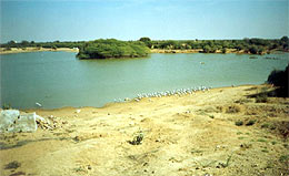 The
whole place was flooded with Flamingoes as well. The view
was breathtaking. Flamingoes are wader birds with long legs
and neck. They have a unique down-bent bill, which helps them
in feeding as they feed with their bills upside down. Believe
me, I spotted Pelicans, Storks and many other birds, which
I couldn’t identify. I rode straight and reached an
island. It was a sheer beauty. Beauty of that small island
lies in its solace, its location in the middle of the flooded
Rann and its proximity to the border, which allows it to remain
less visited. The place is heaven for an ornithologist. This
I came to know after seeing the entries in the register kept
at the BSF post. All of them doctors. One more entry but of
an agricultural chemist :-). From there I could clearly see
the unfinished road. Had this been a finished road, I would
have been only four hours (60kph) away from Bhuj city instead
of seven hours (60kph). The BSF men were very courteous after
thoroughly checking my stuff. They offered me food and whatever
they had there. I declined humbly. The
whole place was flooded with Flamingoes as well. The view
was breathtaking. Flamingoes are wader birds with long legs
and neck. They have a unique down-bent bill, which helps them
in feeding as they feed with their bills upside down. Believe
me, I spotted Pelicans, Storks and many other birds, which
I couldn’t identify. I rode straight and reached an
island. It was a sheer beauty. Beauty of that small island
lies in its solace, its location in the middle of the flooded
Rann and its proximity to the border, which allows it to remain
less visited. The place is heaven for an ornithologist. This
I came to know after seeing the entries in the register kept
at the BSF post. All of them doctors. One more entry but of
an agricultural chemist :-). From there I could clearly see
the unfinished road. Had this been a finished road, I would
have been only four hours (60kph) away from Bhuj city instead
of seven hours (60kph). The BSF men were very courteous after
thoroughly checking my stuff. They offered me food and whatever
they had there. I declined humbly.
Incidentally, the day after was the festival of the ‘Maha
Shivaratri’. I thought, it would be best to be at Koteshwar
Mahadev on this pious occasion. So instead of third section
– Khavda, I proceeded towards the fourth section –
Lakhpat.
^Top
Damsel Cranes
Ravechi, a small hindu religious place en-route, is an another
goddess temple with a large following. It was being renovated.
Here also the food is being served twice a day free of cost.
The place has a small all-season lake adjoining the temple
wall and surrounded by trees. Ravechi fair is famous among
locals during Navaratras. I had to mention the place for another
spectre that I encountered for the first time. I spotted four
large wader birds near the lake. When I was returning to the
main road for Dholavira, I saw a second pond. Seeing the same
birds there, I realized that I was watching one of the migratory
birds, Demoiselle Cranes and that too in overwhelming numbers.
 These
cranes winter here in India and fly all the way from countries
of erstwhile USSR where they breed. Actually, Demoiselle is
a French word, which means ‘Damsel’. They are
big birds with a standing height of approximately a meter
but interestingly they are the smallest of all cranes. Demoiselle
cranes do lot of dancing to strengthen the bonds with their
mates as they make a lifelong pair with only one individual
(monogamous). Both sexes are alike in appearance and have
a light bluish-gray plumage. I was so fortunate to have an
eyeful glimpse of such elegant birds, hundreds of them. As
I was wrapping back my camera, another spectre happened. More
than fifty camels arrived at the lake to drink water, making
their characteristic sound. Few local kids came to me and
asked me to click the “Kujan”. Study prior to
planning a trip helps. I read in the literature that Demoiselle
cranes are called ‘kujan’ locally in India. I
couldn’t get even a word of their language – kutchi
but yes I got this word ‘Kujan’. I told the kids,
I have already clicked them. I guess they were smarter and
got my ‘Hindi’. After clicking the camels, a spectacular
sight that was, I was back on my way to Bhuj. These
cranes winter here in India and fly all the way from countries
of erstwhile USSR where they breed. Actually, Demoiselle is
a French word, which means ‘Damsel’. They are
big birds with a standing height of approximately a meter
but interestingly they are the smallest of all cranes. Demoiselle
cranes do lot of dancing to strengthen the bonds with their
mates as they make a lifelong pair with only one individual
(monogamous). Both sexes are alike in appearance and have
a light bluish-gray plumage. I was so fortunate to have an
eyeful glimpse of such elegant birds, hundreds of them. As
I was wrapping back my camera, another spectre happened. More
than fifty camels arrived at the lake to drink water, making
their characteristic sound. Few local kids came to me and
asked me to click the “Kujan”. Study prior to
planning a trip helps. I read in the literature that Demoiselle
cranes are called ‘kujan’ locally in India. I
couldn’t get even a word of their language – kutchi
but yes I got this word ‘Kujan’. I told the kids,
I have already clicked them. I guess they were smarter and
got my ‘Hindi’. After clicking the camels, a spectacular
sight that was, I was back on my way to Bhuj.
Mata-no-Madh
 Reached
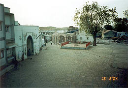
Bhuj at around 4:30 pm. It is a walled city and a definite
destination with the tourists visiting Kutch. Had no time
for the city so headed straight to Mata-no-madh. This Madh
is actually a temple of the Goddess Ashapoora. She has a large
influence in Gujarat and south-western Rajasthan. I reached
Madh at around 10:00 pm in the Night. Food, Shelter or any
such basic need is not a problem anywhere in Kutch region.
I got food and shelter for free wherever I went except at
the Hotels. Please don’t think that since the stuff
was free so quality must have been inferior. In fact, even
the poorest home there cooks quality food. Items…. well
I don’t remember them all. They were numerous. Also,
the host will not stop you…. go on eating till you are
satisfied. Since the entire place has lots of salt, so they
use little sugar in everything :-) Had a very good sleep in
the night after cleaning all my stuff. Reached
Bhuj at around 4:30 pm. It is a walled city and a definite
destination with the tourists visiting Kutch. Had no time
for the city so headed straight to Mata-no-madh. This Madh
is actually a temple of the Goddess Ashapoora. She has a large
influence in Gujarat and south-western Rajasthan. I reached
Madh at around 10:00 pm in the Night. Food, Shelter or any
such basic need is not a problem anywhere in Kutch region.
I got food and shelter for free wherever I went except at
the Hotels. Please don’t think that since the stuff
was free so quality must have been inferior. In fact, even
the poorest home there cooks quality food. Items…. well
I don’t remember them all. They were numerous. Also,
the host will not stop you…. go on eating till you are
satisfied. Since the entire place has lots of salt, so they
use little sugar in everything :-) Had a very good sleep in
the night after cleaning all my stuff.
Koteshwar – The Shiva
 I
started early after darshan of Mata Ashapoora. It was 11:30
when I touched Narayan Sarovar. This small freshwater lake,
adjoining Lord Vishnu’s temple is one of the five holy
hindu lakes in India and is supposedly the westernmost lake
in the country. Also, the Koteshwar Mahadev at the mouth of
the Kori Creek is the westernmost Lord Shiva temple in the
country. There are several Shiva temples in the Kutch region
and the influence of Lord Shiva can be experienced. I
started early after darshan of Mata Ashapoora. It was 11:30
when I touched Narayan Sarovar. This small freshwater lake,
adjoining Lord Vishnu’s temple is one of the five holy
hindu lakes in India and is supposedly the westernmost lake
in the country. Also, the Koteshwar Mahadev at the mouth of
the Kori Creek is the westernmost Lord Shiva temple in the
country. There are several Shiva temples in the Kutch region
and the influence of Lord Shiva can be experienced.
Beauty of sea can be seen from the ramparts of the temple,
which is situated just besides seacoast. Locals informed me
that the Karanchi port lights are visible from here on a clear-sky
night. Unlike Somnath, there is no beach here and the place
is much less famous. It was amazing to believe that I was
at India’s one of the westernmost places.
Spoonful Water
I spotted lots of spoonbills in the Narayan Sarovar while
returning and going to the fourth section of Rann. Spoonbills
were comparatively small wading birds and had unique bills.
Their bills were flat at the end and it appeared as if the
birds have spoon in the place of their bills. They were white
in color and were eating algae in a flock of 20.
^Top
Lakhpat - Abandoned Legacy
 I
started driving along the Kori Creek towards Lakhpat area
as I was missing the Rann badly by then. After a few kilometers,
the road runs parallel to the sea with the shore being only
few hundred meters away on the left. Lakhpat is famous as
a fort township. Presently, only a majestic wall encloses
the township. The creeky landscape, with sea & land playing
hide & seek, gives Lakhpat a unique look. It was a busy
sea-port as the large delta of the river Sindhu enabled ships
to reach deep into the land and leave the port easily with
tides. Lakhpat got developed due to the sea-trade and, in
fact, was named so because the daily income from it was one
lakh koris (the local currency). The whole western creek is
called Kori Creek. I
started driving along the Kori Creek towards Lakhpat area
as I was missing the Rann badly by then. After a few kilometers,
the road runs parallel to the sea with the shore being only
few hundred meters away on the left. Lakhpat is famous as
a fort township. Presently, only a majestic wall encloses
the township. The creeky landscape, with sea & land playing
hide & seek, gives Lakhpat a unique look. It was a busy
sea-port as the large delta of the river Sindhu enabled ships
to reach deep into the land and leave the port easily with
tides. Lakhpat got developed due to the sea-trade and, in
fact, was named so because the daily income from it was one
lakh koris (the local currency). The whole western creek is
called Kori Creek.
Gradually, with time, heavy siltation occurred due to the
tectonic movements of the earth. This shifted the course of
river Sindhu away from Lakhpat towards Karanchi in Pakistan.
The place eventually has become the meeting point of the sea
and the Rann, though it is difficult to make out where the
Rann ends and Sea starts. No more trade turned the, once flourishing
sea-port, into an abandoned legacy. People left the place
slowly and now the total population of Lakhpat is hardly one
hundred, spread in a total of fifteen families, excluding
a Police Station. The town has one old and architecturally
beautiful mosque, a few Shiva temples and a Gurudwara. Lakhpat
is a tourists delight but without amenities. As I visited
some of the Shiva temples there, I came to know that only
left occupation is little bit of agriculture but that too
is dwindling.
BSF posts dot the whole creek and there is one Center of Water
Adventure Sports of Indian Army. I checked it out and was
rewarded by the view of a fantastic seashore alongwith a few
fishermen. There was a huge Guard Tower. The guards spotted
me from a distance but didn’t say anything to me. As
I proceeded towards the Rann, I wondered, how Lakhpat would
have bustled with activities in its heydays. Although, the
Rann is visible from the fort wall as a very wide empty stretch
of flooded land, a more satisfying look can be had by zooming
northwards from the fort to a nearby BSF post. The thing that
makes this terra all the more interesting is the virtual absence
of avian fauna, especially waders. Flamingoes, even otherwise,
are known to prefer non-marine marshes.
^Top
KHAVDA – Rugged Rann
 It
was already 15:20 hours and I had to rush to my third section
of the Rann – Khavda. The route I planned initially
got flopped as the locals persistently discouraged me as the
road was damaged by the recent flooding of the Rann. Therefore
I had to miss the “Haji Pir Ki Dargah” and the
adjoining Rann. ‘That evening when I rode to Khavda’
can itself become a full-fledged ‘landscape’ article.
The unique thing about the landscape of the Rann is that it
can be silty or flooded. Imagine Sun going down or rising
far at the horizon on a clear sky. As good as looking at the
Sun on Sea or Desert. Superb views coupled with quiet evenings
and mornings. It
was already 15:20 hours and I had to rush to my third section
of the Rann – Khavda. The route I planned initially
got flopped as the locals persistently discouraged me as the
road was damaged by the recent flooding of the Rann. Therefore
I had to miss the “Haji Pir Ki Dargah” and the
adjoining Rann. ‘That evening when I rode to Khavda’
can itself become a full-fledged ‘landscape’ article.
The unique thing about the landscape of the Rann is that it
can be silty or flooded. Imagine Sun going down or rising
far at the horizon on a clear sky. As good as looking at the
Sun on Sea or Desert. Superb views coupled with quiet evenings
and mornings.
I reached Khavda at around 19:00 hours. There was a small
cluster of shops and few locals were sitting and chatting
beside the road. I stopped my bike before a shop and asked
the folks for a place to stay. They started enquiring me.
Few moments later, the guys revealed themselves as Intelligence
officials. They informed me that I couldn’t stay in
Khavda as I have not brought the permission from Bhuj. I explained
them that I had no information about the permission. They
asked me to go back to Bhuj and bring permission. This seemed
ridiculous to me as it was already 7:30 pm and Bhuj was 160
kms away and that too involved riding in the night on a bumpy
road. I asked them for the nearest BSF post. They got furious
over my query and said, “Tumse bola naah! Wapas jaao
aur permission leke aaao”. As if I am not an Indian.
I left them then and there and headed straight to the STD
shop. The shopkeeper showed me the way to the Govt. guest
house. Raoji bhai is a friendly fellow in his fourties. I
asked for a room and he gave me one after identification.
I thought it best to explain him what happened with those
intelligence officials because they may trouble him later.
Raoji bhai, though feared those officials, suggested me a
way to protect the mutual interests. In the next few moments,
Khavda found me in the BSF camp, 5 kms off the town waiting
for the ‘Chief’. It was a pleasure to meet Mr.
Leeladhar and Mr. M. K. Rana, his junior. Both BSF officers
not only welcomed me but also assured me a visit to some ‘restricted
areas’ near the Indo-Pak border after verifying my identity
and learning about my interests. I returned to the guest house
and asked Raoji Bhai to talk to the officers. At around 9:30
pm I went to the town to scour for food. I was lucky to find
a local who took me to another local’s house. I had
a sumptuous gujarati meal, the one normally taken in the ‘fast’
as it was the night of the pious Mahashivratri.
The room was excellent and I had a very good night’s
sleep. Next day I was ready by 8:30 am and kept waiting for
the two officers till 10:00 am, when they finally turned up.
They regretted the late arrival due to some off late instructions
from the headquarters and we were off to the one of the most
unexplored regions in the western India. They left me at the
India Bridge where no civilian could step except some privileged
or authorized ones. Oh! What a sight. Unforgettable! On one
side the Rann and on the other a small pool of rainwater flooded
by flamingoes feeding on the algae. Five kilometers beyond
that is ‘Anda Bet’ which is accessible only on
the camel back till recently. Anda Bet is the place where
Flamingoes lay their eggs in the GRK. And mind it. All this
I enjoyed under the deafening noise of the engines of the
Military trucks which kept on trailing one another, incessantly,
till the time I bade goodbye to the guard at the India Bridge.
 Mr.
Leeladhar earlier informed me that had I brought the permission
from Ministry of Environment or Defence, Indo-Pak border would
not be an issue. Then I headed towards ‘Kala Dungar’.
I was informed by the locals that ‘Dungar’ means
a hill in ‘Kutchi’ language. “Kala Dungar”
is the highest hill in the whole Kutch region, most beautiful
and very critical with security point of view. It took me
around an hour to climb to the top. A temple of Lord ‘Dattatreya’
has recently been renovated. It has a strange but true tradition.
The food prepared in the temple premises is taken to a small
hillock twice a day and the priest beats the plate and shouts
– “Lome” many times. The priest informed
me that a fox comes and eats the food and then only we have
our food. Water shortage is the main problem there but a lot
of construction activity was going on. Hill is heavily guarded
by the BSF, Army and Air Force, though the latter has temporarily
moved out from there. Mr.
Leeladhar earlier informed me that had I brought the permission
from Ministry of Environment or Defence, Indo-Pak border would
not be an issue. Then I headed towards ‘Kala Dungar’.
I was informed by the locals that ‘Dungar’ means
a hill in ‘Kutchi’ language. “Kala Dungar”
is the highest hill in the whole Kutch region, most beautiful
and very critical with security point of view. It took me
around an hour to climb to the top. A temple of Lord ‘Dattatreya’
has recently been renovated. It has a strange but true tradition.
The food prepared in the temple premises is taken to a small
hillock twice a day and the priest beats the plate and shouts
– “Lome” many times. The priest informed
me that a fox comes and eats the food and then only we have
our food. Water shortage is the main problem there but a lot
of construction activity was going on. Hill is heavily guarded
by the BSF, Army and Air Force, though the latter has temporarily
moved out from there.
I had little fuel (petrol) left in my tank and I knew fuel
is not available till Bhuj. I approached Army guys and explained
to them my problem. They were very friendly and chatted with
me. After some initial hesitation, they asked me to come after
one hour. They asked me to explore the hills till that time.
After some rock-climbing, I was treated with some breathtaking
views of the Rann. You can guess my enchantment with the Rann
by the fact that I clicked at least ten snaps there. After
one hour, when I returned, I was drenched with sweat. Army
guys offered me food which I humbly declined. They gave me
1.5 Liter of petrol. Not even a single vehicle of theirs runs
on petrol. I thanked those extra-ordinary men in the uniform.
In fact I bowed before them, not for petrol but for the spirit
with which they shared their precious resource without a fee.
Believe it or not!
Then I came back to Khavda, took the rest of the luggage from
the guest house, thanked Raoji Bhai for all the help and hospitality
and headed straight for Bhuj.
On the way, I was struck with a sight which was a lesson for
me. To tell you the truth, I never believed the ‘lome
story’ of the Dattatreya temple at Kala Dungar. And
look at this. What I saw running across the road was a full-fledged
FOX. Yes buddy! A Fox, and that I saw for the first time in
my life, never saw even in a zoo. Dark brown coloured –
a camouflage – and very afraid of me and my machine.
Kept running deep into the Rann taking brief halts to watch
for me if I am following.
I never found time for the Bhuj city. I left the city at around
6:00 pm and stayed in Varahi, little short of Radhanpur. Next
days halt was at my Bua’s place in Pali. There I interacted
with some school children and local leaders. Next day’s
news paper had a news article on my journey and arrival.
HAPPY TRAILS
Paraj Shukla
* More Photos from the ride in the west
photogallery *
^Top
|